
Directions
West Jersey Astronomical Society
www.wasociety.us Last updated
4.07.2025
Regular Club Meeting Site
NE Philadelphia Airport Clear Sky Chart:
Our regular meeting site is the Virtua Health and Wellness Center at 401 Young Avenue, Moorestown, NJ, 08057. It's adjacent to the Centerton Square Shopping Center in Mt. Laurel, NJ (Wegmans, Target, Costco, etc.), and near the interchange of Interstate 295 with NJ Route 38. Click the "Show Map" button at the Virtua link for directions. Go to the Main Entrance, then straight ahead down the hall to the Conference Ctr, Room 155A, or check with the security guard at the front desk.
The following directions to observing sites in the NJ Pinelands, particularly those in State Forests (i.e., Atsion and Batsto) are presented for sanctioned events. Nighttime accessibility under current NJ DEP regulations is disallowed, except for official Public Star Watches at Atsion and Batsto. Otherwise, do not interpret these directions as permission to use any of the sites at will.
Atsion Field (see the accessibility note above)
Carranza Field Clear Sky Chart:

Atsion Field is in Wharton State Forest and is on the east side of Rt 206 about 10 miles south of the Red Lion Circle (the junction of Rts 206 & 70) or 8 miles north of Rt 30 (the White Horse Pike) in Hammonton, NJ. To access the field, enter from Rt 206 through an opening in the guard rail about 150 yd north of Atsion/Quaker Bridge Rd. Here's a satellite view of the field. The address of the Ranger Station in front of the field is 744 Route 206, Shamong, NJ, 08088.
Alternatively, take the Atlantic City Expressway to Exit 28 for Hammonton, but after exiting and turning left onto 54, continue north through downtown Hammonton past Rt 542 until you reach Rt 30 (about 3.2 miles from the exit). After crossing Rt 30, Rt 54 becomes Rt 206, then it's 8 miles north to Atsion. Here's an annotated satellite view of the telescope setup area...
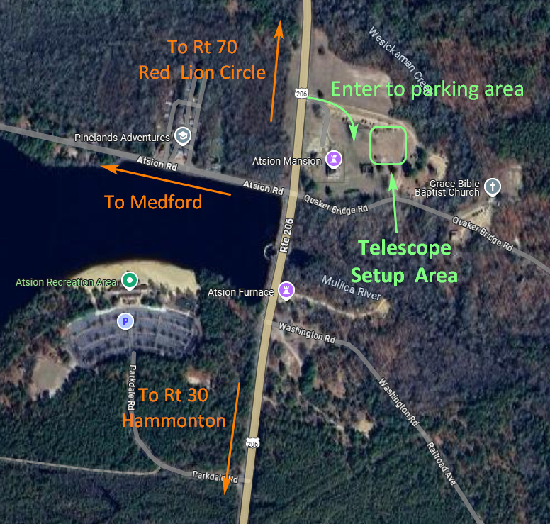
Click the picture for a larger version.
The GPS coordinates for Atsion Field are: 39 deg 44 min 32 sec North, 74 deg 43 min 28 sec West
Batsto Village - NJ (see the accessibility note above)
Batsto Clear Sky Chart:

Batsto is also in Wharton State Forest. From the west, take Rt 30 (the White Horse Pike) east to Hammonton, NJ. About 1.4 miles past the intersection of Rt 206, just before Hammonton Lake, turn left onto Rt 542 (542 is variously known as Pleasant Mills Road, Nesco Rd and Batsto Rd). The address is 31 Batsto Rd, Hammonton, NJ, 08037.
As in the Atsion directions, one could take the Atlantic City Expressway to Exit 28 for Hammonton. At the exit, make a left onto Rt 54 north and go 2 miles to "downtown" Hammonton where you turn right onto Rt 542 (Central Ave) towards Batsto. Go about 1.7 miles to Rt 30, then make a right at the traffic light. Go 150 yards and make a left onto 542.
From Rt 30, continue east on 542 for about 7 miles to Batsto Village which is on your left after a sweeping curve. The entrance road is marked with signs and flagpoles. After turning left onto the entrance road, proceed about 1/4 mile, then turn left towards the Visitor Center. Our star watches are conducted on the large field on your left before reaching the Visitor Center (Update: For 2024, with construction complete, we've moved back to the traditional south side of the road). If you don't have a scope, park in the paved lot in front of the Visitor Center. Here's an online satellite view of the observing site and below is an annotated clip of the view showing the setup and parking areas...
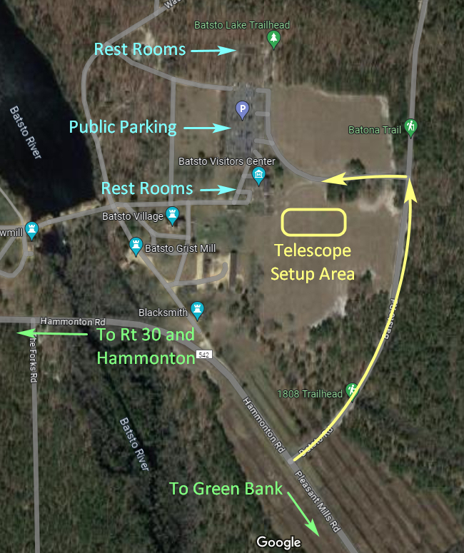
Click the picture for a larger version.
The GPS coordinates for Batsto are: 39 deg 38 min 37 sec North, 74 deg 38 min 45 sec West.
Mt Holly Clear Sky Chart:

Historic Smithville Park is a Burlington County facility, available only for park-sanctioned events, not for personal observing. It's at 803 Smithville Rd, Easthampton Twp, NJ, 08060. It's easily accessed about one mile north of State Rt 38, just east of Mt Holly. The traffic light on Rt 38 at Smithville Rd is 0.8 miles east of the Wal-Mart light on Rt 38 and 0.9 miles west of the light at the intersection of Rts 38 & 206.
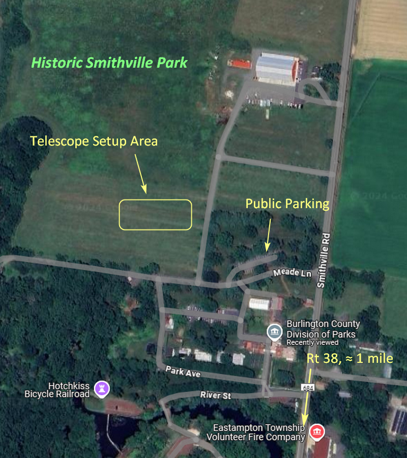
Click the picture for a larger version.
The GPS coordinates for the Smithville observing spot are: 39 deg 59 min 17 sec North, 74 deg 45 min 06 sec West.
Barnegat Road Observing Site (accessible to members, only along with a key holder for the locked gate)
Astropheric Weather Forecast:

The Barnegat Rd Observing Site is in Greenwood Forest WMA, Woodland Township, NJ, and is under the authority of the NJ Forest Fire Service aviation division. It's on the north side of Rt 72 (also known as Barnegat Rd), 10.7 miles southeast of the Four Mile Circle, which is the junction of Rts 70 & 72. After the 10.5 mile marker, watch for the Smokey Bear sign on the right, the gravel entrance road is just past it on the left. Here's a street side view of the entrance road approaching from the west (the Four Mile Circle). If you're coming from the east, the entrance road is 3.0 miles west of the traffic light at Rt 539. If coming from the west and you reach the traffic light, turn around.
The GPS coordinates for the Barnegat Site are: 39 deg 49 min 07 sec North, 74 deg 25 min 18 sec West
Cherry Springs State Park, Pennsylvania
CSSP Clear Sky Chart:

Here are Jim Mack's directions and maps for CSSP as presented at the August 5, 2011, WAS meeting. Here's the Black Forest Star Party directions page, which includes GPS coordinates and a map of the field at CSSP. Check with the Pennsylvania DCNR for accessibility and costs associated with CSSP.